How Science Influences WPC’s Land Conservation Efforts
The Western Pennsylvania Conservancy uses historical data, science and modern technology to prioritize and effectively accomplish its land conservation work.

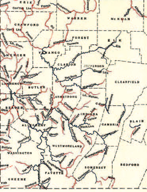
A map of waterways in Western Pennsylvania as published in A.E. Ortmann’s 1909 study. Ortmann identified the “good condition” waters in red and the “unfit for life” waters in blue.
For example, French Creek and its surrounding lands in northwestern Pennsylvania comprise one of the most ecologically rich regions in the state and, as such, have long been one of WPC’s priority conservation areas.
Even a century ago, A.E. Ortmann, a curator of invertebrate zoology at Carnegie Museum and an expert on Western Pennsylvania waterways, cited the exceptionally diverse fauna and clean water of French Creek.
In “The Destruction of the Fresh-Water Fauna of Western Pennsylvania” — a report Ortman published in 1909 rating streams for their biodiversity and health — he noted that French Creek and its tributaries were generally clear and possessed one of the best collection grounds for all forms of freshwater life.
This report played a significant role in informing WPC scientists about the importance of French Creek and guided their conservation efforts. In 1969, WPC purchased a wetlands area near French Creek to help safeguard the watershed’s habitat.
Data collected using geographic information systems (GIS) and through the Pennsylvania Natural Heritage Program’s county inventories of plants and animals contribute significantly to WPC in its mission to protect land, watersheds, floodplains and the rare and endangered species that live there.
WPC assessed what was influencing water quality and used the data to create a watershed conservation plan for French Creek. As part of the implementation of the plan, Watershed Conservation Program staff members work with farmers to reduce pollution runoff from livestock and crops into the stream and its tributaries.
In partnership with watershed ecologists and hydrologists from other organizations, WPC identified and evaluated the French Creek floodplain and determined that letting the creek flood naturally would significantly improve its health. They set out to protect the floodplains by discouraging development in these areas.
“The Western Pennsylvania Conservancy uses its strong science programs to help the land protection staff target the most important properties to protect in Western Pennsylvania and to evaluate specific properties,” said Shaun Fenlon, vice president of land conservation. “Few conservation organizations have the benefit of scientific staff to develop property-specific plans, provide insight during meetings about properties, and to visit properties with land protection staff. Regular biweekly land protection meetings use state-of-the art computer mapping to illuminate the values of possible land protection efforts with the most up-to-date scientific knowledge. It is a synergy that is second to none.”
This approach has led WPC to define the French Creek and Lake Erie Shoreline as one of its four key conservation regions. WPC land conservation specialists continue to learn more about the value of French Creek, and to date, more than 3,800 acres of this special watershed have been protected.
Science and research influence decisions about which land to preserve and protect throughout the region, including the Conservancy’s three other key conservation regions: Pennsylvania’s Northern Woods, the Laurel Highlands and Central Valleys and Ridges.
Fenlon said, “The Conservancy’s work in places like French Creek is a direct result of long-term research and thoughtful planning by science and land protection staff. As the Conservancy moves forward to protect the exceptional places of Western Pennsylvania, it will continue to leverage the tremendous scientific expertise that it has.”
