|
Conserve |
|
|
The Allegheny River |
| A River in Three Parts |
| Allegheny Islands |
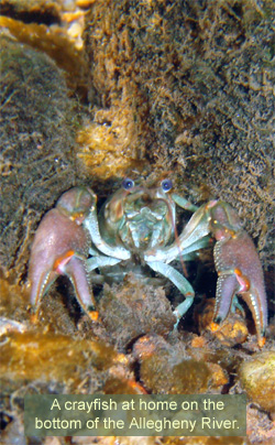
| Life at the Bottom |
| French Creek |
| Little Mahoning Creek |
| Past Issues |
| Home |
�
Getting to the Bottom of the Allegheny River
 This past May, WPC staff began
a project that had never been attempted in the Allegheny River -determining and then mapping in
detail the waterway’s depth. The rich
and detailed information gathered
from this project will assist WPC and
our community partners in developing
a long-term conservation plan for this
globally important natural resource.
This past May, WPC staff began
a project that had never been attempted in the Allegheny River -determining and then mapping in
detail the waterway’s depth. The rich
and detailed information gathered
from this project will assist WPC and
our community partners in developing
a long-term conservation plan for this
globally important natural resource.
River depth is one key measurement which, along with information about the flow of the river, type of riverbeds, water quality and aquatic life populations, helps create a more comprehensive picture of river habitats and river health. Electronic information gathered through this project will be shared broadly with other public and private organizations to improve the region’s understanding of water quality and assist in the development of best practices to manage this important natural resource.
WPC’s staff has been conducting research for this mapping project (called bathymetry) carefully and methodically. Driving a 23-foot research boat in an “S” pattern upthe river at approximately three miles per hour, staff made a grid of the river channel. During this course, a GPS sonar device marked depth points every three seconds. In a typical work day, staff collected more than 6,000 data points in order to record depth, boat speed, water temperature, time, date and other relevant information.
“We’re not using expensive
equipment,” said WPC’s Director of
Aquatic Science, Eric Chapman. “It’s
basically a $700 fish finder with the
fish signal turned off, but it gives very
clear depth readings.”
By the end of October, the team had covered more than 31 river miles, from Allegheny Pool No. 5, located about ten miles south of Crooked Creek, up through Allegheny Pools Nos. 6, 7 and 8. A little further upstream is the town of East Brady in Pool 9, which is the northernmost section of the river that can be commercially navigated.
WPC staff then processed and
analyzed the data points, either for
display as a grid or conversion into
contour lines on a topographic map. They also created
numerous 3-D fly-over videos that
allow for a unique, never-seen-before
view of the Allegheny River’s bottom.
This view will enable understanding of
all types of river topography - ranging
from shallow, pristine areas to deep,
60-foot trenches.
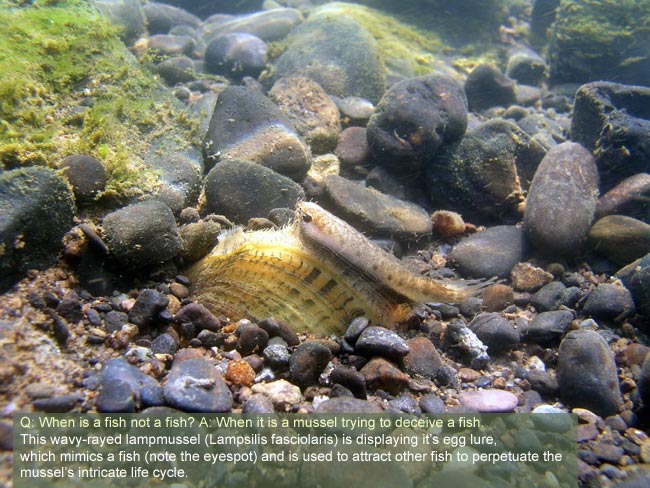
A WPC companion study to the bathymetry project has uncovered many species of freshwater mussels, fish, and macroinvertebrates in the Allegheny River Lock and Dam section. Species identified include rare and endangered mussels from Pools 4 and 8, such as the northern riffle shell (Epioblasma torulosa rangiana) and the round pigtoe (Pleurobema sintoxia).
WPC is currently completing Pool No. 4, located near Freeport. Still ahead is the plotting and mapping of the Pittsburgh Pool (beginning at the Point and extending to Lock and Dam 2 at Aspinwall), Pool No.2 (from Aspinwall to Lock and Dam 3 at Acmetonia), and the C.W. Young Pool (from the dam at Acmetonia to Lock and Dam 4 at Natrona).