
Remote but Rewarding
Glade Run
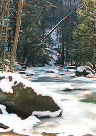
In Dunbar Township, Fayette County, Glade Run cuts through a wild mountain landscape. Challenging to access, the stream rewards visitors with numerous waterfalls, and with large hemlocks and native plants lining its banks.
“Because the stream flows through a portion of State Game Land #51 and a secluded, steep mountain valley with little intrusion from human activity, its aesthetics remain relatively unspoiled,” said WPC Watershed Manager Mark Killar. Black bear, bobcats, and fishers have been seen in the area.
Glade Run
Glade Run drains from Chestnut Ridge into Dunbar Creek and eventually into the Youghiogheny River.
“The terrain can be very challenging to traverse and timber rattlesnakes have been reported in the area. However, if wild and unspoiled mountain stream landscapes are appealing to you, then the effort is worthwhile,” said Killar. “The best time to visit is in the late spring through the fall when water levels are usually lower. Access from the headwaters area gate is only available during hunting seasons; otherwise it is a very long walk.”
A recovering brook trout stream, Glade Run has been impaired by mining in its uppermost headwaters and is impacted by acid rain. The Western Pennsylvania Conservancy has provided technical assistance to local groups in order to improve its water quality for several years.
In addition, WPC has provided technical support for a special project of the Chestnut Ridge Chapter of Trout Unlimited (CRTU) that has begun to reestablish a naturally reproducing brook trout population in the stream after nearly fifty years. Despite this early success, however, brook trout population numbers remain low, said Killar. “Although legal, fishing could place undue stress on the fish,” he said.
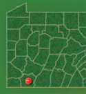
Directions: The stream may be accessed from State Game
Land #51. Travel south on State Route 119 from Connellsville.
Turn left onto SR 1053 and follow it to the town of Dunbar.
From Dunbar, follow Dunbar Creek upstream along SR 1055 to
a dirt road adjacent to the Game Lands Maintenance
Headquarters on the right, several miles upstream. Follow the
dirt road to the right upstream as far as possible and park
adjacent to Dunbar Creek. From there, hike Dunbar Creek
upstream until reaching the mouth of Glade Run on the left. It
is a long and difficult hike, and at certain points, it usually
requires crossing Dunbar Creek. Remember to proceed with
extreme caution if water levels are high, as the rocks are
slippery and the current mostly fast.
GPS coordinates: -79.60226 39.91591
Here's one more "Remote but Rewarding" destination, Otter Rock.