
Remote but Rewarding
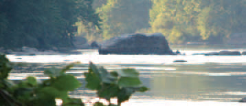
“Otter Rock,” Ohiopyle State Park

One of Pennsylvania’s most beloved state parks, Ohiopyle encompasses 20,500 acres, of which 11,795 acres were conserved by the Western Pennsylvania Conservancy. Within this vast natural area in the Laurel Highlands, a well-hidden spot for picnicking and wildlife-watching has become a favorite of Fallingwater Director and WPC Vice President Lynda Waggoner, and her husband, Tom Waggoner.
“Local people might have a different name for it, but we call it Otter Rock because nearly every time we have been there as the sun goes down, we have seen otters in the river and sometimes frolicking on the rocks,” said Lynda Waggoner.
Located less than a mile from the bike trail parking lot at Ohiopyle, the spot is nonetheless difficult to access. “There is no clearly defined path from the bike trail to the rock and it is well-defended by poison ivy,” said Tom Waggoner. “To get there, you must clamber down, up, over, and among sometimes slippery rocks, and you should be able to identify poison ivy.”
"Otter Rock"
But the experience that awaits nature lovers, particularly at sundown, is worth the trouble. “What I like about going here is that the character of the river changes at this time of day,” said Lynda Waggoner. “The boaters are gone and a peaceful quality settles in. It is a joy to watch as the native residents come out. We have not only seen otters, but also Hooded Mergansers and a couple of times we have been visited by minks who weren’t at all shy.”
Directions: The stream may be accessed from State Game
Land #51. Travel south on State Route 119 from Connellsville.
Turn left onto SR 1053 and follow it to the town of Dunbar.
From Dunbar, follow Dunbar Creek upstream along SR 1055 to
a dirt road adjacent to the Game Lands Maintenance
Headquarters on the right, several miles upstream. Follow the
dirt road to the right upstream as far as possible and park
adjacent to Dunbar Creek. From there, hike Dunbar Creek
upstream until reaching the mouth of Glade Run on the left. It
is a long and difficult hike, and at certain points, it usually
requires crossing Dunbar Creek. Remember to proceed with
extreme caution if water levels are high, as the rocks are
slippery and the current mostly fast.
GPS coordinates: -79.49061 39.86984