
Wildlife-Watchers’ Bliss
Enlow Fork
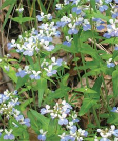
Blue-eyed Mary at Enlow Fork.
When WPC board member Dan Nydick first visited Enlow Fork during the 1980s, he was enchanted. “It feels really remote, even though it’s not that far from civilization,” said Nydick. “I was struck by the variety of wildflowers, and especially by the Blue-eyed Mary. You don’t see it in very many places.” Since that first visit, he has returned to Enlow Fork once or twice each year – alone or with family.
“It’s a great place to share. I’ve got pictures of my daughters in the field with flowers where we were picnicking,” he said.
Enlow Fork Natural Area was conserved by WPC, with support through a key land donation from CONSOL Energy, from 1983 to 1985. The 1,190-acre reserve includes steep valleys with trillium and twinleaf growing on hillsides; domestic flowers such as daffodils in areas that once had houses; and bottomlands with Blue-eyed Marys.
“It’s also wonderful for birds – indigo buntings, scarlet tanagers, yellow-throated warblers and many others,” said Nydick. “I’ve seen a wide variety of birds with very little effort.”

Erin Nydick, daughter of WPC board member Dan Nydick, at Enlow Fork in 1995.
A stream at the bottom of the reserve is popular with local anglers – and one or two lone fishermen are often the only people to be seen on the entire reserve.
A former country road runs through the property (now closed to traffic), enabling easy walking access to the site. The best time of year to visit is the peak of wildflower season, in late April or early May.
Directions: Take I-79 south from Pittsburgh to Washington,
Pa., then take I-70 west to exit 11. Drive on Route 221 south
for approximately seven miles to Route 18. Route 18 turns to
the right. Follow Route 18 to Route 231 and turn right (north)
toward E. Findley. After a short distance, Route 231 goes right.
Continue straight on State Route 3026 to the intersection with
Ackley Creek Rd (SR 4007). At this intersection proceed
straight ahead and cross a small metal bridge. Follow this road
up the hill for about two miles to a sign on the right for Game
Lands #302. Turn right (very sharp right) and follow the gravel
road downhill along a small stream to a small parking area at
the end of the road. The last couple of miles onto the property
are somewhat bumpy in a smaller car.
GPS coordinates: -80.46211 39.96167