Land Conservation

Conserving Priority Landscapes

The beautiful and varied landscapes of Western Pennsylvania range from high plateaus and mountain ridges to vast forests and rich river valleys. These lands and waterways provide and sustain native, rare, threatened and endangered plants, animals and ecosystems that, in some cases, are found nowhere else on Earth. Our region also provides endless recreational opportunities that make Western Pennsylvania a destination for nature lovers, anglers, paddlers, hikers and hunters alike.

Using science, research and information as our guide, the Western Pennsylvania Conservancy has prioritized the following landscapes as important areas to protect land and waterways and restore water quality in order to provide our region with clean waters and healthy forests, wildlife and natural areas.

These landscapes are shown on the Conservation Blueprint, the Conservancy’s map of conservation priorities.

Land-Ohio-and-Lower-Allegheny-Tom's-Run-Allegheny-general-woods-on-uplands-above-Little-Run-Vert-PgW-Autumn-400x300

Ohio and Lower Allegheny Region

The Ohio and Lower Allegheny Region extends to Bradys Bend, Pa. at the north and is bounded by the foothills of the Laurel Highlands to the east. From there, it extends to the west where Pennsylvania meets the West Virginia border. The Allegheny, Monongahela and Ohio rivers meet at the point in Pittsburgh and are integral to the social, cultural and economic fabric of Western Pennsylvania. Beyond their important economic and recreational value, the Ohio River and its tributaries represent one of the most diverse freshwater ecosystems on earth.

In addition to the rivers, the region contains important wetlands including wetlands with higher pH water, known as fens, high quality streams, varied lands with abundant flora and fauna and lands capable of supporting locally grown food for the Pittsburgh metropolitan area. This region includes lands that provide a range of outdoor recreational opportunities within a short drive, and accessible to thousands of local residents. Pittsburghers can easily “get away from it all” and enjoy rural and rustic escapes, and be home by dinner.

Land-Preserving-Priority-Landscapes-IMG-4101-FIA-Clermont-Winter-400x300

Upper Allegheny Region

The Upper Allegheny Region comprises the drainage of the Allegheny River as it flows northwest from a spring in Potter County into New York State before bending southwest to the Kinzua Dam on its way to Pittsburgh. Along this path, it inherits a litany of fishing-destination streams: Potato Creek, Tunungwant Creek, Kinzua Creek, Brokenstraw, Tionesta, Oil Creek, French Creek and the Clarion.

The region includes a mix of glaciated and unglaciated landscapes that supports some of the most diverse, productive and scenic forests and rivers in the Eastern United States. At the heart of the region is the 500,000-acre Allegheny National Forest, Pennsylvania’s only national forest and a linchpin of a 7,600 square mile mosaic of wilderness, working forests, wetlands and farmland that make up the Upper Allegheny Region.

Clarion River

Land-Protecting-Land-Clarion-River-Inholding-IMG-0837-trees-water-Winter-400x300
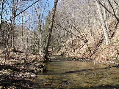
The Clarion River flows nearly 100 miles from its headwaters in McKean County to its confluence with the Allegheny River near Foxburg. Once considered one of the most polluted streams in the state, the Clarion River has recovered to become an important recreational destination. In 1996, a 52-mile section from Ridgway, Pa. to the Piney Dam was federally designated as Wild and Scenic. Bald eagles now nest along the river and sightings of ospreys and otters are common.

Since 1977, we have conserved more than 13,000 acres along the Clarion River Corridor. Most of this property has been made part of the Pennsylvania’s public lands system, including Clear Creek and Cook Forest state parks, state forest lands, state game lands and the Allegheny National Forest.

French Creek

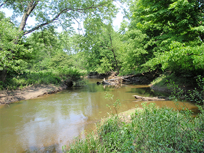
The French Creek watershed is a 1,250-square mile watershed that flows from its headwaters in Chautauqua County, N.Y. to its confluence with the Allegheny River in Franklin, Pa. It is the most biologically diverse stream of its size in Pennsylvania or any state in the northeastern United States, containing more species of fish and freshwater mussels.

French Creek and its tributaries are home to four federally endangered freshwater mussel species, known as the Northern riffleshell (Epioblasma torulosa rangiana), rayed bean (Villosa fabalis), snuffbox (Epioblasma triquerta) and the clubshell mussel (Pleurobema clava), as well as one federally threatened freshwater mussel species, known as the rabbitsfoot (Quadrula cylindrical cylindrical). There are about 86 species of fish that call the watershed home.

Historically, the Ohio River drainage (including the Allegheny River system) was one of the most biologically diverse river systems in the nation with respect to aquatic species. In the last 100 years, human impacts to these watersheds have resulted in the loss of many species, thereby leaving French Creek as the best representative of historical biodiversity in the Pennsylvania portion of the Ohio River basin. WPC’s Natural Heritage work in French Creek has produced a thorough understanding of the status of living resources in this area. The Conservancy has been involved in the French Creek watershed since the late 1960s.

Land protection efforts continue to date with over 5,000 acres permanently protected. These properties are maintained as natural areas and all of our properties in this area are open to the public for outdoor recreation that includes hiking, hunting, fishing, canoe and kayaking and bird and wildlife watching. The French Creek watershed also includes the more than 8,000-acre Erie National Wildlife Refuge and four Audubon Society Important Bird Areas.

Land-Lake-Erie-Shoreline-400x300

Lake Erie Region

The Lake Erie Region encompasses Pennsylvania’s Lake Erie coastline and tributary watersheds. Besides providing recreational opportunities vital to the local economy, the region exhibits unique, high quality ecological features that make a significant contribution to maintaining the diversity of the overall Lake Erie ecosystem.

The Lake Erie shoreline includes high sand and clay bluffs, scrap seepages and remnant wetland forests that support many rare species. Another unique feature of the Lake Erie shoreline is Presque Isle peninsula and bay. Presque Isle is a unique complex of beaches, sand dunes and sandplains that is constantly being eroded and re-deposited by the action of lake currents, waves and storms. The dynamic nature of these shorelines contributes greatly to the region’s unique species diversity. These landscapes are also important habitat for several rare reptiles and many species of shore birds. While they represent only a small portion of the Lake Erie ecosystem, the Lake Erie Region tributaries support aquatic ecosystems unlike any other streams in Pennsylvania.

Scenic View at Laurel Hill State Park

Laurel Highlands

The Laurel Highlands are a special place in Pennsylvania. Part of the Allegheny Mountains, the Laurel Highlands stretch from the Conemaugh River south into Maryland. The Laurel Highlands are known for their diversity of plant and animal life, forested mountain ridges, pristine streams, recreational opportunities and scenic beauty.

The significant variety of landscapes in the Laurel Highlands produces a high level of forest community diversity. Lower slopes and coves support rich, mixed forests dominated by tuliptree, red oak, eastern hemlock, sugar maple, American beech, pawpaw and basswood. Sandstone and limestone rock formations embedded within mature forests create micro-habitats relied upon by many plants and animals. Forests high on the plateau and mountain ridges encompass species, rich bogs and other non-riparian wetlands. Intact forests on mountain ridges are also important corridors for migratory birds.

Flowing through the forestlands of the Laurel Highlands are its streams and rivers. Many of the cool, shaded streams in the region are able to maintain their quality because of low levels of human disturbance. Many of these streams are popular recreational resources for anglers.

Along the banks of the Lower Youghiogheny River, including along the lower reaches of major tributaries such as Indian Creek, lies a unique complex of plant communities. Both river-bank and floodplain-dwelling plants exist among the bedrock outcrops, rock shelves, boulder fields, cobbles and gravel bars characteristic of high gradient streams and rivers. Depending on the effects of natural disturbance factors such as flooding and ice scour, these plant communities and species may include sycamore floodplain forests, sycamore scrub and patches of big bluestem and Indian grass. Since 1951, we've protected more than 83,000 acres of the Laurel Highlands’ rivers, forestlands, wild areas and scenic ridges.

Ligonier Valley

Farm in the Ligonier Valley
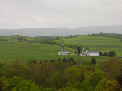
The Ligonier Valley is an important component of our Laurel Highlands priority conservation landscape. Since 1979, we’ve been working to conserve the unique features of this valley. Our Mountain Streams Project has added 9,600 acres of land to Forbes State Forest in the valley, while more than 10,000 acres of private land has been protected through conservation easements. This long history of conservation successes is the result of collaboration and a shared vision between the Conservancy and many landowners in the valley. By using a variety of conservation techniques, the program works with the local community to protect and enhance the unique natural character of the Ligonier Valley and the greater Laurel Highlands region.

Flanked by Chestnut and Laurel Ridges, the valley features two of the Conservancy’s priority watersheds, Tubmill Creek and upper Loyalhanna Creek. The forested ridges provide habitat for several species of special concern whose habitats are being threatened, including Allegheny woodrat and Indiana bat. The forests of the valley provide important corridors for wildlife movement and water quality protection. Our conservation efforts in the valley focus on protecting these ecologically significant features.

WPC - Easement Properties

Central Ridges and Valleys Region

The Central Ridges and Valleys Region encompasses the Potomac River tributary watersheds of Pennsylvania, the Juniata River basin and the State College region. It covers a large portion of Pennsylvania’s section of the Chesapeake Bay Watershed.

The region is characterized by long, forested mountain ridges interspersed with picturesque rural valleys dominated by farmland. This region also hosts thousands of acres of public land, protecting large areas of forestland that are available to the public for outdoor recreation. Many of the valleys are drained by high quality coldwater streams that support healthy populations of trout and attract anglers from around the world.

Land-West-Branch-Susquehanna-2012-05-22-Blakeslee-water-Spring-400x300

West Branch Susquehanna Region

The West Branch of the Susquehanna River is the largest tributary system of the Susquehanna River. This river and its tributaries make this region an area of contrasts. Its northern tributaries, such as First Fork Sinnemahoning, upper Kettle Creek and Pine Creek, flow through expansive state forests and are some of the highest quality streams in the state. However, the southern tributaries, including the headwaters of the West Branch, Clearfield Creek and Red Moshannon, have long been impacted by resource extraction and acid mine drainage.

Governmental agencies, nonprofit organizations and volunteers work to address these impacts with success. For example, the Bennett Branch Sinnemahoning Creek was once a dead, red-stained stream, but is now stocked with trout. The West Branch of the Susquehanna Region is characterized by vast high plateaus cut by deep valleys and contains approximately 1.7 million acres of public land. This, more than any other factor, has helped to sustain the health and wild character of the region.

For More Information:

Western Pennsylvania Conservancy
Land Conservation Department
800 Waterfront Dr.
Pittsburgh, PA 15222

Phone: 412-288-2777
Toll-free: 866-564-6972
land@paconserve.org